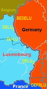
The
Common German-Luxembourg Territory is formed by the rivers Our,
Sauer and Moselle, where these run on the border between Luxembourg
and the German states of Rhineland-Palatinate and Saarland.
The
Border Treaty
Article 1 of the German-Luxembourg Border Treaty
[3] of 19 December 1984 states that the boundary line goes where the Moselle, the Sauer and Our ran on the signature day of the Treaty of 26 June 1816, and represents a common territory which is under the sovereignty of both states. This also applies to the airspace as well as for the underground and the existing islands in the rivers. If a river, either by natural reason or by artificial transformation, is changed, the two countries develop according to Article 7, a new regulation by a Boundary Commission.
Article 2 states that a German area of a size of 3.9632 hectares is on the western side of the River Sauer. In contrast, the Luxembourg area is of an area of 4.6878 hectares to the east side of the Our.
According to the 1816 treaty the islands within these waters belong to either of the states, and are thus not condominial. The islands were divided by the states according to the Protocol of Emmerich. After 1816 several islands have disappeared, and others have formed
[7].
On 15 March 1988 the draft law No. 3157 was The German Bundestag decided to turn the law on 14 April 1988.
The German-Luxembourg treaty was finally approved on 1 September 1988. The border had been accurately mapped, and the customs documents to ensure that the border remains verifiable.
Geography
The
totally 134.195 km long German-Luxembourg border is followed by
almost the entire length of the Our-Sauer and Moselle river system,
over a length of 127.979 kilometers. Only in Vianden area at the
Our, Luxembourg extends over a length of about six kilometers east
of the river system.
While 9,91 km is Saar-Luxembourg land border, the remaining 118 km form the
Rhineland-Palatinate-Luxembourg boundary.
This length is reached by a great number of river bends, because the
distance as the crow flies is only about 67 km.
The
northern 50 km of formed by the Our. The northernmost point is the border
triline Belgium – Germany-Luxembourg, near the Europe Memorial.
In
the area of the district Walldorf-Reisdorf the Our confluences with
the Sauer, wherefrom she continues as a border river. The Sauer flows into
the Moselle River at the border of the municipalities of Langsur and
Oberbillig.
Between
the German communities Waldhof-Falkenstein and Roth is the only place
where Luxembourg comes on both banks of the river, namely the town of Vianden.
In
south the Sauer condominium is slightly shorter, 42 km.
The southern section of 26.42 km length of the Moselle River (between
river kilometer 205.870 and 232.290 formed). The Saarland-Luxembourg in
Moselle condominium is only 9,91 km long (between river kilometer 232.290
and 242.200).
The joint German-Luxembourg territory has a surface area of 700.92 ha (7,01 km²) of which 698.34 ha is water surface, while the small islands together make up an area of 2.58 ha (25,800 m²). It is important to make clear that it is in this area is not a legal vacuum.
There
are therefore two contigious parts of the condominium; north of Vianden and south of
Vianden.
– The "ends" of the condominia (the "trilines") are
straight lines.
– The condominium is limited by the line where land and water meet at
normal water height (Mittelwasserstand).
– There are dry parts of the condominium; several dams (large and tiny),
locks, power plants, bridges, bridge fundaments and other installations.
– The condominium extends below and above ground, in the same way as
ordinary borders do.
– The islands are now [de facto] part of the condominium. This is
based on practicality.
–
Islands which have existed since 1816 might be de jure enclaves inside the
condominium.
– Several of the islands mentioned in the Protocol of
Emmerich exist no more, and others have formed.
– The borders are amply marked. There are primary (52 pairs), secondary
and tertiary border stones. At some bridges there are brass plates, at
others tin plates. Where the border traverses dry ground, such as at dams
and locks and some bridges, there are small cast iron circular plates.
There is also a handful of metal bolts at selected places. [8]
German
statistics [6] operates with an estimated river area of 6.21
[also 6,20] km² which is calculated from an average
river width of about 50 meters. At
the border triline Germany-Belgium-Luxembourg the Our is 10 meter wide. At
the mouth of the Sauer, the border spreads to 30 m. At the mouth
of the Sauer into the Moselle she goes from 50 to 110 meters, and until the
Saarland border, Moselle flows with a width of 110-120 meters.
There
are at the time being 15 islets in the river system. The largest are more
than 200 m long and more than 70 m wide. With time they change their shape
as well as new islands come into being while other disappear.
Of the 15 islands in Our and Sauer 9 of them islands are newly created,
and what concerns two of them, it is doubtful whether they are old or new
[7].
The
bridges are subject to the joint maintenance of both states. The largest bridge is the
Sauertal Bridge (A64 / E44). At Langsur a railway bridge goes over the the
Sauer, just before it flows into the Moselle. Additionally, there are
21 road bridges and 7 pedestrian bridges.
In
the area of the German-Luxembourg condominium is the port of Mertert
(Luxembourg). The Moselle Stadtbredimus and Grevenmacher locks are
explicitly excluded from the condominium.
History
The
creation of the condominium was agreed in the German-Luxembourg Border Treaty of
19 December 1984, where the detailed questions of the borderline were set.
It was based upon the Final Act of Vienna of 9 June 1815 and the border
treaties on 31 May 1815, 26 June 1816 and 7 October 1816 between the
Netherlands and Prussia.
Different
interpretations of the definition that the boundary waters
"should belong to both countries together," had led to several
differences between the neighboring countries and at different court
decisions. The negotiations was initiated in 1925
With
the 1958-1964 canalization of the Moselle to a major waterway it once again
became urgent to
clarify the situation. In 1979 negotiations on the border regime between Luxembourg and Germany
was initiated and were
completed in 1984 with the completion of a new border treaty.
German
Administration and Structure
In
the German official statistics, the condominium was since 1 May
2004 [6] as a "free community area" of
the state Rheinland-Pfalz with an area of 6.20 km². The area is different than
the rest of the community-free areas, in the sense that no county and no county
government was assigned, but the two adjacent counties of Eifelkreis Bitburg-Prüm and
Trier-Saarburg of the former administrative district of Trier were touched.
The
ten-kilometer-long section where the Moselle is the boundary between the
Saarland and Luxembourg, however, is not a separate area. The areas in
this part of the condominium are pro forma attached to the adjacent
communities (Perl and Schengen).
According
to the district directory of Rhineland-Palatinate the area is divided in 47 communal
districts (river sections), each named after the nearby
municipality of pairs on each side of the border, as to the
municipality reform in Rhineland-Palatinate (7 June 1969 to March 16,
1974) existing communities.