Jan
S. Krogh's Geosite: Tripoints
of America
|
|
|
|
|
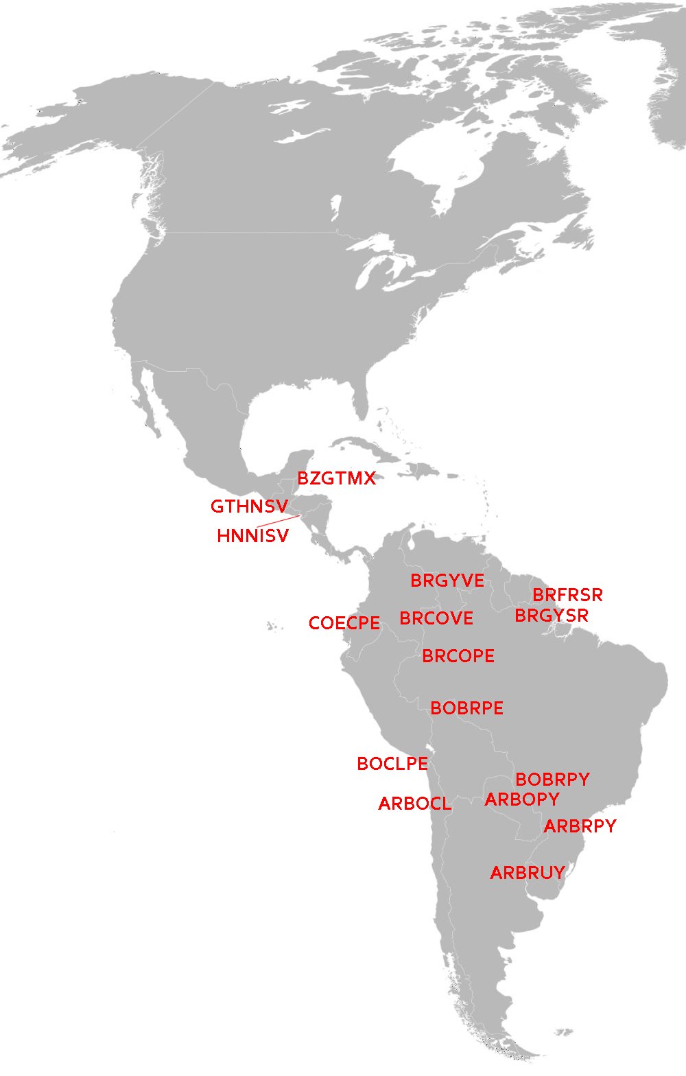
Click
on the tripoint you want to explore. |
|
| No. |
Tripoint |
Countries |
Name |
Position
(appr. unless otherwise stated) |
Dry/Wet |
Remarks |
|
| 1 |
ARBOCL |
Argentina
- Boliva - Chile |
Zapaleri |
22°48'30"S
67°10'40W |
D |
5600
msl.
Photo
of the tripoint area #1 |
|
| 2 |
ARBOPY |
Argentina
- Boliva - Paraguay |
|
22°14'59"S
62°38'44"W |
W |
264 msl. |
|
| 3 |
ARBRPY |
Argentina
- Brazil - Paraguay |
3
Fronteiras |
25°35'33"S
54°35'37"W |
W |
97
msl.
Hering:
http://www.geocities.ws/mafiapetedk/othertp.html |
|
| 4 |
ARBRUY |
Argentina
- Brazil - Uruguay |
|
30°11'43"S
57°38'46"W |
W |
Disputed.
38 msl. |
|
| 5 |
BOBRPE |
Boliva
- Brazil - Peru |
|
10°56'44"S
69°34'20"W |
W |
230
msl.
Re.
Borderbase. |
|
| 6 |
BOBRPY |
Boliva
- Brazil - Paraguay |
|
20°9'56"S
58°10'9"W |
W |
77
msl.
Re.
Borderbase. |
|
| 7 |
BOCLPE |
Boliva
- Chile - Peru |
Tripartito |
17°29'54"S
69°28'7"W |
D |
4124
msl. Photo
of tripoint. |
|
| 8 |
BRCOPE |
Brazil
- Colombia - Peru |
Tres
Fronteras |
04°13'00"S
69°56'00W |
W |
63
msl. |
|
| 9 |
BRCOVE |
Brazil
- Colombia - Venezuela |
3
km NW of Cucui airport |
1°13'9"N
66°50'59"W |
W |
79
msl.
Re.
Borderbase. |
|
| 10 |
BRFRSR |
Brazil
- France - Suriname |
|
2°19'33"N
54°33'16"W |
W |
French
Guiana. 472 msl. |
|
| 11 |
BRGYSR |
Brazil
- Guyana - Suriname |
|
1°56'3"N
56°30'1"W |
W |
559
msl. |
|
| 12 |
BRGYVE |
Brazil
- Guyana - Venezuela |
Monte
Roraima |
5°11'00"N
60°46'00"W |
D |
2280
msl. Photos of tripoint from
BR side, from
VE side. |
|
| 13 |
BZGTMX |
Belize
- Guatemala - Mexico |
|
17°48'56"N
89°9'7"W |
D |
144
msl.
Photo
of tripoint. |
|
| 14 |
COECPE |
Colombia
- Ecuador - Peru |
Güeppi |
0°6'57"S
75°15'26"W |
W |
193
msl.
Re.
Borderbase. |
|
| 15 |
GTHNSV |
El
Salvador - Guatemala - Honduras |
Cerro
Monte Cristo |
14°25'13.75"N
89°21'21.35"W |
D |
2384
msl. Re.
Donner & Nielsen 2011. Westernmost tripoint in the
world.
Photo
of tripoint. |
|
| 16 |
HNNISV |
El
Salvador - Honduras - Nicaragua |
Golfo
de Fonsca |
13°07'30"N
87°33'01"W |
W |
0
msl. |
|
|
|
|
|
|
|
|
|
|
|
|
|
|
|
|
|
| This page was first time created
on 6 April 2012. This page was last time updated 02/06/13 . |

|