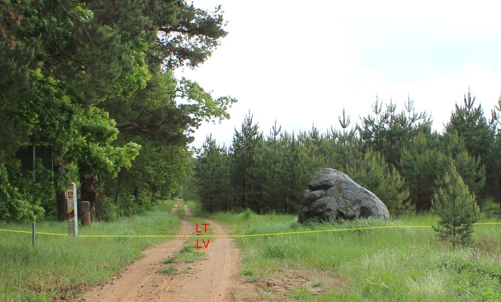
LTLV-0458
Back ] Next ]


Up

Jan S. Krogh's Geosite: Latvia - Lithuania Boundary Points LTLV-0458 (Griežė, LT / Griezes muiža, LV)

The boundary watched from Latvian side towards Lithuanian side.  The 
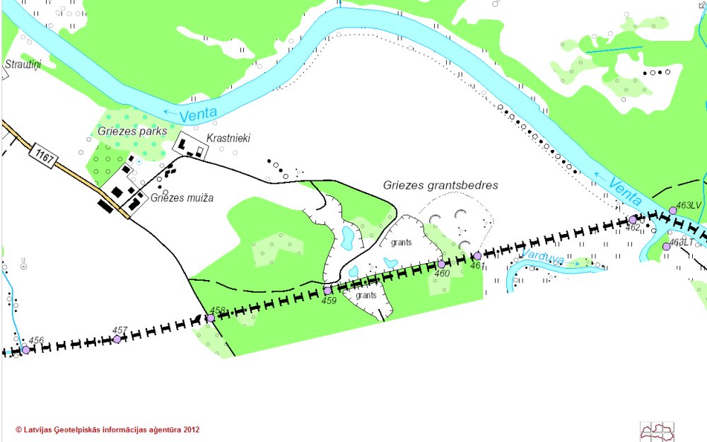
crossing point is 340 m south of the manor of Griezes muižas (LV) and 700 m north of the manor of Griežės dvaras (LT). 
Position: 56°25'19"N 22°11'29"E (WGS84). 
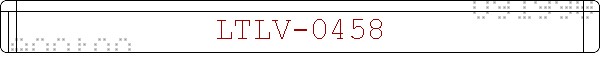
The boundary marker no. 0458. 
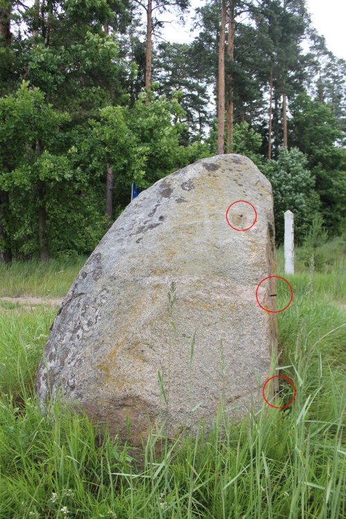
Old hewn nature stone with inscription which might be of Curonian origin. Courland is now a Latvian landscape.  It is most likely a border stone between two manors from the 18th century.  Similar stones are the Russian verst (distance) markers, but since this road never was any major road this is very unlikely to be the explanation here. 5)  
At Griežė (LT) and as well as at Grieze (LV) there were manors, Griežė Manor in Lithuania was run until World War II. 9)  One of the landowners was Kaiserling, Baron of Griežė. The manor on Latvian side is still being run. The Latvian manor is situated close to the village of Kalni. In 1888 the church significant Latvian sculptor Karlis Zale was baptized in Grieze Evangelic Lutheran Church on the Latvian side. 10)
The upper line seems to say K..rlen and the second Griežer.   Grieže or Grieze is the name of the village which is divided by the border. Similar stones have been found in Western Courland as well as other places in South Latvia. 8) 

The boundary watched from Lithuanian side towards Latvian side.

Same as above, but from a slightly other angle.  The boulder to left might also be an older Couronian-Livonian-Lithuanian tripoint marker. 

On the boulder which is located slightly inside on Lithuanian territory we found three rebar remains left inside the stone (marked with red rings). No inscriptions were found, but a big part of the stone is covered in moss. We did no attempt to remove it. 1700 metres by road southeast from this point (at 56°24'53"N 22°12'30"E) there is a quarry and the boulder might come from there. 7)

Watched from west towards east. The border marker in the background. 

The top rebar. 

And the two rebars on the vertical southern side of the stone. 

Watched from east towards west. The northern edge of the boulder seems to touch or almost to touch the boundary, but it is barely inside Lithuania. 

The point (marked with blue circle) was in medievel times a tripoint between Courland, the district of Hasenpoth in the province of Piltene (in red) and Lithuania. Piltene was for a short time in the 1570s under king Magnus of Livonia. 2)  The province was from 1611-1795 mainly under the Commonwealth of Lithuania-Poland. 

The point is located a few hundred metres south of Grieze's Mill and less than one km west of the Venta River.

The point was visited in June 2012.

Sources and links

  1. Vidzeme manage to discover unknown boundary (About Vidzeme border stones from the 17th - 19th century, in Latvian - Latvijas Petroglifu centrs)

  2. Livland voivodship of Polish-Lithuanian Commonwealth

  3. Chronology for Newfound Candidate Rock of Ages

  4. Latvian Geospatial Information Agency Map Browser (with LTLV border marker numbers quoted)

  5. Fast miles Russia by E. Kochnev (in Russian)

  6. The Semigallian cultural area by Ilona Vaškevičiūtė

  7. Griezes karjeras (Wikipedia)

  8. Correspondence with Mr Andris Grīnbergs, Head of Latvijas Petroglifu centrs (LPC), June-July 2012.

  9. Griežės dvaras  (Mažeikių krašto enciklopedija)

  10. Griezes luterāņu baznīcas drupas (Vietas)


This page was first time made on 13 June 2012. This page was last time updated 26/04/15 .