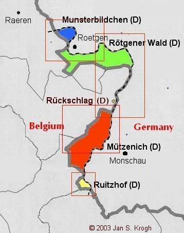
Five exclaves created by the territory of a former Belgian railway
track that cuts into German territory between the German towns of Rötgen and
Monschau, south of Aachen. Belgium owns the territory of the former railway track, making enclaves out of the five pieces of land separated from
the rest of Germany. In 2009 the railway track was removed since the railway
ceased its activity in 2001, but the boundary is
not changed. Parts of the former railway is replaced by a bicycle
track.
The exclaves are called (from north to south) Munsterbildchen,
Rötgener Wald, Rückschlag, Mützenich and
Ruitzhof.
Munsterbildchen
enclave. Measured to be about 182,6 ha and with an estimated population
on about 50 persons.
Rötgener
Wald enclave. Rötgener
Wald comprises the southern parts of the town of Rötgen. Measured
to be about 998 ha, and with an estimated population on about 1000
persons.
At boundary marker no. 750 it may look on this
Belgian map like the Mützenich enclave is connected to Germany proper over the
railroad. But the Germans, who show the road as Belgian would surely be
the most likely of the two parties to show it correctly if it was German.
Therefore we conclude that Mützenich is a German exclave.
Ruitzhof
enclave. Measured to be about 93,7 ha and with an estimated population
of about 70 persons.